| Birding trip
report Western South Africa + Namibia 23 Oct. - 15 Nov. 2003 John van der Woude, http://johnbirding.wolweb.nl |
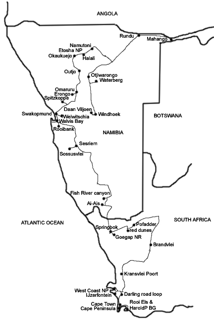
| Summary and logistics (below) |
| See also: - Photos of sites: South Africa (2 MB), Namibia (south and west) (1.3 MB), Namibia (central and north) (1.3 MB) - Species list (Excel file; with summary of itinerary). See also our reports of 2006 (west central) and 2005 (east). |
| This was a great trip to
a totally new region. We (my wife Nollie, also a birder, and me) started at Cape Town, for the
Cape specialties plus the Cape flora, and then went up
along the West Coast and the dry interior of western
South Africa to Namibia. There we drove through the wild
scenery of the Namib desert to the famous Walvis Bay
region, and then along the Erongo mountains and Etosha
national park to the Okavango river in the savannah
region in the northeast. We rounded the trip off with
visits to the Waterberg and the Daan Viljoen parks in
central Namibia, and flew home from Windhoek. The
distances involved are large, but the roads are so empty
that you don't have the feeling of making long distances
but the feeling of being in a nature film all the time. For the exact dates of this itinerary, see the species list. |
| We consulted several trip
reports for orientation on this region (see www.eurobirding.com),
but in the end we totally relied on the books written by
Callan Cohen c.s. This was 1. Essential Birding in
western South Africa by Callan Cohen and Claire
Spottiswoode (partly also published at their web site www.birding-africa.com), and 2. a draft version of the
Namibia chapter of: "Southern African BirdFinder -
where to find 1400 species in southern Africa and Madagascar" by Callan Cohen, Claire
Spottiswoode and Jonathan Rossouw (Struik, 2006).
We regard these books of such great value that we
will not go into much detail in the present report and
rather refer to these books. The text below is meant as
supplementary to these books. (However, see some additional
maps ) During the preparation for this trip, I had some additional e-mail contact with Callan Cohen and Eve Holloway, both of Birding Africa (www.birding-africa.com). Eve gave us some very valuable tips for accommodation. She can also do all the bookings for you. |
|
| The roads in both
countries are good, also the unpaved roads (which are
well maintained). Rental cars in South Africa are not
expensive, but the drop-off in Namibia is rather
expensive. Still, the total sum for our Opel Corsa Sedan
1600 cc (with ample space in the boot) was good compared
to what we would have paid in many other countries. Both
countries have a rather high standard of living (in
general) but lodging and food are cheap in South Africa
and only a bit more expensive in Namibia. We had not made
reservations for the hotels and lodges (in order to have
a flexible itinerary). In case a lodge would be full we
had brought our small tent as well, and we needed it
twice. We found the safety nearly a non-issue, we never had any feeling of danger. We found the people very friendly and civilised. For us Dutch it was a strange experience to hear so much old Dutch ('Afrikaans') around us, and not only from whites. We spoke mostly English, but in Namibia also German. Malaria can occur in northern Namibia in some seasons, but not when we were there (so again we brought our Malarone pills back home, for a next trip). We had nearly only sun, except the first weekend which was so windy and cold (with some showers) that the pelagic trip was cancelled. We didn't regret that too much because we saw from Cape Point the really high waves, and we are sure that we will back in the Cape again some year (if only for the flowers). Temperatures rose steadily while we drove north, and in northern Naimibia it was nearly 40 degrees Centigrade. In fact it was too dry there, the rains should have come earlier for the crops. The first real showers were there on our last days. For South Africa it had been too dry as well, in the period before our arrival (even so that the famous yearly flower period of early September had been far less spectacular, we were told). |
| Apart from the
birdfinding guides mentioned above our other literature
was the field guide by Sinclair et al. (Birds of southern
Arica, 3rd edition), the Carruthers wildlife guide (a
wonderful book), and the Loneley Planet guides for both
countries. For South Africa we used the maps in Essential
Birding plus a map of the whole of South Africa. For
Namibia we used the official and outstanding 2003 map
that was sent us for free by the Namibian Tourist Board
in Germany. We used a reference minidisc with bird sounds that we had taken from Guy Gibbon's Southern Africa's Bird Sounds. We had brought our (light-weight) scope and we were really glad we had done so, because in these open areas you will often spot birds at a large distance. |
| The species list reflects
the wide range of habitats covered in this trip, from
penguins at the windy Cape to skimmers along the Okavango
river, and from Cape Siskin in the fynbos vegetation to
Dune Lark in the Namibian coastal desert. This range
could even have been wider if we had chosen to include
some afrotropical forest east of Cape Town (esp.
Grootvadersbosch) but we knew beforehand that this trip
would not be our only visit to South Africa so we keep
that habitat for later. We had a sort of wish-list of (near-)endemics
for the whole region we visited, and we saw nearly all of
them. The worst dip was Gray's Lark in the Namibian
coastal desert, but this was generously compensated by
Red Lark and Dune Lark. In general this is a lark region,
although the numbers were smaller than we had expected (not
the number of species!). As lovers of chats and other
small Turdidae we had a good time as well. Don't underestimate how many mammals you'll see here. Our mammal list (given at the end of the bird list) eventually counted some 35 species. So obtaining a wildlife or mammal guidebook is essential. This can be done in the bookshops of the botanical gardens near Cape Town (Harold Porter and Kirstenbosch), which are obvious sites to start your birding trip anyway. |
| Below we give some
notes about the birding sites, supplementary to the
birdfinding guides mentioned before.
The texts for
South Africa are somewhat less detailed than for Namibia,
because for SA the book Essential Birding gives plenty
details. See also the texts at the photo section of this
trip report. |
| It is wise to plan to
stay for a long weekend at the Cape, in order to have a
chance of joining a pelagic trip. This must be booked
well ahead e.g. at www.capetownpelagics.com or www.annealbatross.org.
The trip may be postponed from Saturday (the preferred
day) to Sunday if the weather is not good. Keep in touch
by phone once you are there. There are many good birding sites on and within an hour from the Cape. We found e.g. the Rooi Els site quite good: both Cape Rockjumper and Ground Woodpecker at GPS 105, which is about 600 meter walking down the track from the gate. To find the gate: leave the main road in the bend at GPS 108, and keep left at the fork after a while. At the small Jonkershoek Dam reserve close to Afton Grove lodge we had both Cape Siskin and Cape Rock-Thrush. |
| We found West Coast
national park a must, if only for a good chance on seeing
the Black Harrier (we had it three times in the northern
part, first near the Seeberg hide). We were glad that we
decided to stay the night before close to the park, at
Falcon's Rest in Langebaan. The drive up to that place
via the so-called Darling road (see the birdfinding guide)
was a very pleasant one, birdwise (e.g. Blue Crane, Pin-tailed
Widow, White-throated Swallow, Cape Longclaw) and for the
scenery. Don't miss the small Tinie Versveld grassland
reserve, we had the Cloud Cisticola in the taller grass
in the lefthand part. |
| Seeing all four marine
cormorants is a wish of many birders. We built up this
list gradually, starting at the penguin colony of
Boulders, but in the end (while finally adding Bank
Cormorant) we saw all four of them together at
IJzerfontein just south of West Coast NP (scope needed). |
| Bushmanland and
Namaqualand form the northern half of western South
Africa, and we choose to do the long detour via Brandvlei
and Pofadder to Springbok. If you are short in time, you
can go straight up north to Springbok and from there go
up and down to Pofadder. On the other hand, the road
along Brandvlei, although on the map depicted as being
narrower than the direct N-road to Springbok, was at
least as good, and is certainly worthwhile. The hotel at Brandvlei (phone 054 6030002) was simple but OK, also for dinner. The very long unpaved road from Kennhardt to Pofadder can be easily avoided by driving up north from Kennhardt and turning left onto the N14. After some 20 km the N14 is one of the fastest roads you'll ever have driven: it is also used as a test road for speeds up to 250 km/h - with permit only! The hotel in Pofadder was rather good, with a friendly staff. A visit to the red dunes in the western part of the Pofadder area is a must. We had the really red Red Lark at GPS 112, which is about 700 m past the corral with its fence made of old tyres. The Goegap national reserve near Springbok is quite impressive. It is open from 8 a.m. (not 9) and you can enter until 4 p.m., and you are permitted to stay until dusk (7 p.m.). It is a 10 to 15 minutes drive from Springbok. We had Ludwig's Bustard flying nearby at c. 400 m after the start of the tourist loop drive, and there are a lot of Capped Wheatear. In Springbok we had a very nice room in the Undulata guesthouse, which is signposted when you follow the main road south from the town centre. Along this same road we had a nice open air restaurant opposite a very obvious ATM (cash machine, also for Cirrus). |
| Crossing the border to
Namibia took about 30 minutes, you have to go from one
small office to the other all the time, with forms and
stamps etc. We just asked one of the friendly official
guys every time where we had to go next. |
| Several people had told
us that Ai-Ais is a must, scenically at least. It is a
detour but not a very long one (about 80 km from the main
road). However, once you are there and also visit the
large canyon, it is very tempting to stay on the gravel
roads and drive on to Sesriem for the next major scenic
site in Namibia, the Sossusvlei area with its enormous
dunes, inside the Namib-Naukluft national park. And after
that you'll have another long stretch of unpaved roads to
Walvis Bay. Well, we did it, and we made it. Birdwise
however, it may be better to keep the main road all the
way from the border to Walvis Bay. Yet we were glad we
did this very scenic tour, especially for the Sesriem
area, and it also produced some very good birds that we
did not see afterwards again: Rüppell's Bustard and
Temminck's Courser along the road from Sesriem to
Sossusvlei (14 km past the campsite), and a splendid
Freckled Nightjar in the lights of the Ai-Ais campsite. At Ai-Ais we easily got an apartment giving direct access to the (very) hot spring water pool. At Sesriem we had to camp, maybe we better had tried one of the simple lodges along the approach road we drove from the north. However, this is still 50 km or so before the gate of the national park, and you have to be early on the road to Sossusvlei, not only for the birds but also to fully enjoy the spectacular form and colour of the dunes. The campsite has a reasonable little shop (with beer and water of course), and a petrol station. If the official camping places are all occupied, you are allowed to camp in the ample space between these, but this will be an even sandier business than on the official spots themselves. |
| The most important bird
to see in Namibia is probably the endemic Dune Lark. We
found it at GPS 113, and we got there as follows. Take
the C14 inland, out of Walvis Bay. At 6.7 km from the
roundabout where you leave Walvis Bay, take the side road
D1983 right signposted Rooibank, a fast unpaved road, and
follow this for 24 km. At that moment you see a fenced
settlement in front of you, with a very large gate across
the road. Well before this gate, and just after a side
road going left, there is a sandy track going right (the
junction forms a sort of triangle; I think it was the
only track going right; it functions as a bypass around
the fenced settlement). Follow this sandy track for at
most 300 m because after that it becomes too sandy (for 2WD).
Park here, we had a good spot on the left well before the
first Coca Cola sign. Walk on along the same sandy track
until you see a second Coca Cola sign. This is close to
the fence of the settlement, and a little before three
large eucalyptus trees (the largest trees in the whole
area). Just after this second Coca Cola sign the track
splits, and take the righthand track here. You are now in
the sandy river bed area with small dunes with some
vegetation, but mostly bare sand. We had the lark after
about 200 m, singing, and walking across the small dunes,
at about 8 a.m. |
| In Walvis Bay (Walvisbaai)
a must is the long road west to Paaltjies, leaving the
main road several km south of town. We drove the
Paaltjies road as far as allowed and had a very good time
with waders. The Protea hotel in Walvis Bay was probably the best accomodation we had on the whole trip. Very nearby are a good supermarket, a petrol station and a lovely restaurant called Crazy Mama's. |
| We used the maps and
other info in the Lonely Planet guide in order to find
the Welwitschia drive inland from Swakopmund. This is a
long drive, and if you only go there to see the
Welwitschia plants (like we did), then it is not
necessary to do the whole drive (we didn't anyway). Drive
on along the C28 and take the side road left near the
relict Van Stryke mines. From there you will have the
plants soon, after a few km. |
| Note that most street
names have changed in Swakopmund since the publication of
the 1st edition (2002) of the LP guide of Namibia. We got
the permit for the Welwitschia drive (random checks only)
at the spacious information office at a crossing along
the former Kaiser Wilhelm street. On the other side of
the crossing is a very good internet-café called
CompuCare, where I had the contents of my digital
camera's memory sticks burned onto a CD, for a very
moderate sum. Bring your own USB connection cable, unless
you use CompactFlash. I had phoned them before from home
to ask about this possibility - saved me the cost of
extra memory sticks. Their phone number is +264 (0)64 463
775. You can easily operate Swakopmund from Walvis Bay, no need to have a hotel there. |
| We have missed the Gray's
Lark both at Rooibank and north of Swakopmund. On
hindsight we should have operated as follows. On your
first morning in Walvis Bay you will probably drive on
quickly to the Dune Lark site (like we did), and not stop
to try the Gray's Lark along that D1983 (see above). So
on the second morning (if this is your last day there
before driving on to the Spitzkoppe etc.) do the D1983 as
a very early pre-breakfast site only for Gray's Lark.
Then have breakfast at the hotel still at an early hour
and then drive on along Swakopmund to the Spitzkoppe and
be there probably before 10 a.m. |
| Along the road from
Swakopmund to the Spitzkoppe we discovered a site for
Orange-River White-eye. This is at GPS 114, in the trees
at the Nonidas garage to the right of the B2, about 11 km
from Swakopmund, and 1 km before the D1901. Ask
permission at the office to walk around. They assured us
that future birders would be welcome if they ask
permission. There were at least 5 of these birds present
in the trees, in fact immediately after entering the
premises. |
| A few hours at Spitzkoppe
is something you should not miss if you drive the B2. If
you are very keen on seeing the Herero Chat you need
probably more than that, I even think that you have to
camp there in order to have the late evening and the
early morning. The campsite is rather basic, but it is a
great place, between the giant rocks, and amidst some
lovely shrubs and trees. |
| On your way from
Spizkoppe to Omaruru, forget the gloomy town of Usakos
quickly (though it's the first place after Swakopmund
where you can get petrol, there is none at Arandis as the
map suggests). In Omaruru, birders stay often at the
friendly hotel Staebe, and so did we because we entered
the town too late to explore the Erongo Wilderness lodge.
This lodge is much more expensive, but has a splendid
location. Nevertheless, we saw all the birds we wanted
along the public road running to and along the wilderness
lodge, the D2315. We saw them as well before the large
gate in the road as just after it. The gate is not the
gate of the wilderness lodge (that gate is 200 m further
on, to the left), but just a sort of state checkpoint for
the whole Erongo Wilderness area. We had to wake up the
guard but he was very friendly. Indeed we were here
already before dawn, and had a shooting star. This
brought us much luck, we had a wonderful morning here
with twenty trip ticks including several nice ones like
Hartlaub's Francolin, Rosy-faced Lovebird, Monteiro's and
Damara Hornbill, White-tailed Shrike, Cinnamon-breasted
Bunting and Rockrunner. |
| In Omaruru we also paid a
quick visit to the Omaruru Rest Camp, a wooded campsite.
We actually saw two Woodhoopoes at the front, but these
passed too quickly to be identified as Violet. To the
back there is a new fence now, so you cannot walk from
the campsite into the dry river bed anymore. We also
tried the D2329 a bit north of Omaruru, to the right.
There were some nice trees after 2 km or so, with
Groundscraper Thrush (also present at the campsite) and
Purple Roller in the wide river bed. |
| If you can't make it all
the way from Omaruru to Okaukuejo in Etosha NP, then
staying at Outjo is an option. The Bushfeld Park lodge is
2 km N of Outjo and this was a good place to stay and
have dinner, and they had nice birds as well (Violet-eared
Waxbill, Pririt Batis and others at the bungalows;
Carp's Tit uphill - follow their nature trail). From this
lodge it is a one hour drive to the Etosha gate. The good
road is empty in the early morning, but there can be some
game that has passed the fences, so watch out to save the
game, yourself and the car. Outjo has a large and good
supermarket, so it is a good idea to stock up here before
entering Etosha NP. |
| Etosha is a great place
but you may not wish to stay there very long when it is
so dry as during our trip. In fact we stayed only two and
a half day in Etosha, of which only one night (at the
lovely bungalows of Namutoni camp, with a good buffet
restaurant): this night was sufficient for seeing e.g.
Double-banded Sandgrouse, and we could do Halali camp in
a few hours as some of the local workers were so friendly
to show us the owls during midday (we gave them a tip of
course). Some other supplementary details for Etosha: the vegetated Leeubron water hole (not far from Okaukuejo) had a perched pygmy-falcon near the Sociable Weaver colony; Verreaux's Eagle-Owl was roosting in the large tree at the border of the Okaukuejo water hole; the Namutoni water hole had, at dusk, not only DB sandgrouse but also a roost of maybe 10.000 Red-billed Quelea, visited shortly by a Red-necked Falcon. As a matter of fact, you must take enough time to watch the mammals also. |
| On the way from Etosha to
Rundu (for the Okavango strip) you pass Roy's Camp and we
asked for a lunch there. The friendly staff prepared us
just the light meal we wanted. Meanwhile, we saw some
nice birds around the dining place, especially the Black-faced
Babbler for which this camp is known. They also have a
nice shop for indigenous handicrafts. |
| Once you cross the border
of the Kavango province, the B8 passes along a much more
real Africa than anything you have seen before in Namibia.
More and poorer people, straw huts, but also larger trees.
At one of the last stalls before you enter the Rundu
area, we bought some very nice craft (on the way back).
In Rundu we stayed at the very green Sarasunga lodge,
with some good birds around the bungalows (like Meyer's
Parrot). The lodge is signposted from the old road going
east from Rundu centre along the river, which is the same
road that also passes the sewage works a few kms further
on. For a visit to this birding site (the main one for
Rundu), we parked our car along the road and walked the
trail along the eastern rim of the ponds. The car seems
safe there, as there is quite some traffic all the time.
Do walk all the way down along the sewage ponds, cross
the open sandy valley, and check the reedbeds. We had a
glimpse of a Marsh Owl there. In Rundu there are good shops, and ATM's (cash machines). |
| In contrast to what I had
expected from other reports, the Popa Falls lodge and
campsite did not make a pleasant impression on us, when
we inspected it for the last bungalow available. Maybe it
was just too dry there to be nice. We were glad we had
driven on to Mahango Lodge, further on along the Okavango
river. This may be an expensive option if you stay in the
lodge itself, but as it was full we had to camp. Their
campsite is quite nice and we were helped very friendly
and efficiently by the owner (anglo-german) and his
personnel. Of course we shared the very good evening
meals in the lodge, for a reasonable rate. We had brought
enough food from Rundu to have something for breakfast
and lunch in the field. Hippo's visit the lodge grounds (also
the campsite) at night but there is apparently no need to
be afraid, as we initially were. Still, it may be best to
put your tent not so in the open grass along the river as
we did, but seek a more sheltered place between the
bushes. The lodge is close to the Mahango reserve, a splendid area where we had many good birds and mammals. The road from the main road at Divundu down to Mahango is a dirt road with some tricky spots of more loose sand than you are used to, so drive more careful than we did otherwise you will also get stuck in the sand. Also the track from this road to the Mahango lodge is a bit sandy: we just had to keep to the track and not try to bypass it. |
| Shakawe in Botswana is
some 15 km further on along the Okavango river, but this
requires some more days, and moreover it was fully booked
(learnt that by phone well before we left home). Find out
before whether you are allowed to cross the border with
your rental car, and at what cost. |
| If you cannot make it all
the way south to Waterberg you can also stay at
Otjiwarongo town, we stayed there at the comfortable
C'est Si Bon lodge (although again in one of the last
rooms available). Their restaurant was also good. From
here it is about a one hour drive to the Waterberg
Plateau park. The bungalows in the park itself look quite
nice, in a good setting for birding also, but they can be
visited by baboons. An elderly German couple came back to
their bungalow just after they had met us on a walk along
the cliff face, and found that despite their bungalow
being well locked, the baboons had broken into the
bungalow and had ravaged it in search of food. |
| The Daan Viljoen park
west of Windhoek is a nice birding site, and an obvious
destination if you stay your first or last night in this
capital. Please mind that the dam (a focus site for
birding) is all the way at the end of the tarred road (we
were first looking for it at the wrong side of the lake...).
The trail going up directly from the parking place at the
dam to the viewpoint produced some of our best birds of
the trip (Short-tailed Rock-Thrush and Diederik Cuckoo). Windhoek itself is not a very scenic city, but does have some special things like the House of Gems where you can buy nice minerals and necklaces. Park your car right in front of the shop. Catering at the airport is minimal, so don't count on a good last meal there. The flight across Botswana to Johannesburg is quite impressive, if you secure a seat on the (left) window. |
| * * * |
| GPS measurements referred
to above (all in WGS84):
GPS 105 S34°18'41,57" E018°49'17,79" GPS 108 S34°18'10,32" E018°49'12,28" GPS 112 S29°20'07,87" E018°58'26,34" GPS 113 S23°11'05,80" E014°38'43,64" GPS 114 S22°38'40,51" E014°37'21,43" To these I add waypoints measured on
Google Earth: (Note: 50 m aberration can occur) South Africa:
Penguin reserve
Boulders Enter for Rockjumper
site 2003 Rooi Els Darling rd start Tinie Versveld
reserve Parking & pier -
cormorant watch Yzerfontein Presumed start
Kransvleipoort rd Best part of
Kransvleipoort? Road to Goegap Turn-off from highway
for Red Lark Namibia: Sossusvlei lodge ? Turn-off to Rooibank Gate of Rooibank Dune Lark 2003 Turn-off to
Welwitschia drive Enter here for
Welwitschia Nonidas garage Or-r
White-eye turn-off for
Spitzkoppe Spitzkoppe entrance? rd to Erongo W Lodge Waterberg Plateau NP
entrance? Rd to Daan Viljoen
park Daan Viljoen park House of Gems
Windhoek |